The Interactive World Maps WordPress plugin allows you to generate an unlimited number of maps with colored markers and interactive features for nations, countries, or regions.
Interactive World Maps is well-suited for:
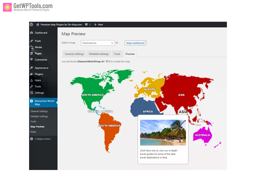
- Travel Websites: Construct maps to showcase destinations and link to pages providing information about specific locations.
- Traveler Websites: Exhibit a map featuring visited destinations or countries.
- Small Companies: Illustrate the business location on a country map.
- Multinational Companies: Develop maps highlighting the cities or countries where they operate.
- Infographics: Present easily interpretable maps with diverse information.
- NGOs: Generate maps showcasing NGO projects worldwide.
Explore various applications and let your creativity flourish!
Interactive World Maps Features:
- Show Different Regions
- You will be able to show hundreds of different kinds of maps, already included:
- A map of the entire world.
- A continent or a sub-continent. (Africa, Europe, Americas, Asia, Oceania, and all their sub-continents)
- A country. (virtually all the countries in the world are included, featuring the most requested: USA, United Kingdom, Canada, France, Germany, Spain, Italy, Brazil, India, Australia…)
- A state in the United States.
- The United States is divided into metropolitan areas.
- A state in the United States is divided into metropolitan areas.
- A country is divided by its regions.
- You will be able to show hundreds of different kinds of maps, already included:
- Color Regions or add Markers
- You can add active colored regions to the map, and display them in 2 different ways:
- As Markers -It will display a colored bubble in the chosen regions, which can be a city, a state, or a country.
- As Regions – It will color the whole region, for example, a continent, subcontinent, country, country province, or a US state.
- You can add active colored regions to the map, and display them in 2 different ways:
- Add Interactivity
- You can add interactivity to the active regions:
- An Action? You can set up different kinds of actions for when the user clicks in an active area. You can make a new URL open, or simply display a message. Advanced users will be able to create their own Javascript functions for customized actions, like opening information with a lightbox effect.
- A Tooltip- A tooltip will be displayed by default on hover with the information you provide.
- You can add interactivity to the active regions:
- Customizable
- You will be able to customize the visual of your maps:
- Inactive regions color;
- Background color;
- Box border width and color;
- Markers size;
- Width and Height of the map;
- Individual colors for each active region;
- You will be able to customize the visual of your maps:
- Responsive
- Interactive World Maps uses the powerful Google Geochart API which creates SVG vector maps.
- Cross-device and browser-compatible
- By Interactive World Maps Add the Maps anywhere on your website
- Compatible with all the popular WordPress Themes
- Including Divi, Avada, X Theme
- CSS Hacks made easy